

The Nebraska Sandhills


Sandhill Landscape
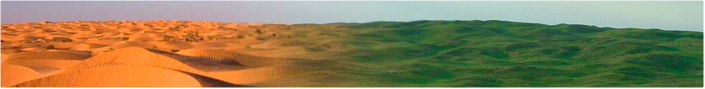
The Nebraska Sandhills is one of the most unique areas in the world. Spanning almost 20,000 square miles (one-fourth the area of Nebraska), it is the largest sand dune formation in the Western Hemisphere. Following the last ice age, wind took hold of the loose sand, blowing it into vast dunes reaching up to nearly 400 feet in height and stretching 20 miles across the landscape. Precipitation allowed grassland plants to take root in the shifting sand, eventually stabilizing the dunes and holding them in place. Throughout the history of the Sandhills, major droughts have occurred several times, resulting in less plant life and more exposure of the sands to the wind. Consequently, different areas have shifted during the past several thousand years. In more recent times, the Sandhills have been carefully managed by cattle ranchers in order to preserve the stability of the dunes so that they do not revert back to a desert-like state.
Another unique aspect of the Nebraska Sandhills is that it is resting on one of the largest aquifers in the world. The Ogallala Aquifer consists of 1 billion acre-feet of ground water and comes above the surface at the base of many dunes. Thus the Sandhills is a region of dry and sandy grassland dunes with many thousands of lakes and wetlands scattered between them.
The landscape of the Sandhills can be divided into six main classifications: choppy sands, sands, sandy, sub-irrigated meadow, lakes & wetlands, and blowouts. To learn more, click on any of the above photos.


